Showing posts with label Arthur Street. Show all posts

Wednesday, November 4, 2015

LEST WE FORGET.....WE WILL REMEMBER.....on the 11th hour of the 11th day of the 11th month.......

Remembrance Day 2015

All gave some.......some gave all.

     Below is a photo of my father (in the blue square) at 23 years old in the Remnants division, 2nd Ack Ack Battery, Royal Canadian Army, Canadian Army in Victoria BC on July 20th 1942.  At this time these soldiers were guarding the fleet in the Victoria BC harbour from possible attack after Pearl Harbor.      My father Jon was one of the lucky ones....after Victoria and after some time in England he was able to return to his family after the war years to live a long life here in Fort William and Port Arthur.  He just passed away this past January at the ripe old age of 95.

Next is one of two incredible photo/postcards of the Algonquin Regiment on their way down the hill on Arthur Street (now Red River Road) in Port Arthur heading to the CPR train station, June 14, 1941...and then off to war..... 
Click on photos to enlarge...


This is what the corner on Arthur (Red River Road) and Water Street looks like today.  The only recognizable building is the pillar on the old Pagota tourist building.


The soldiers of the Algonquin Regiment are about to board the Canadian Pacific Railway on Water Street in Port Arthur in 1941.  I can't imagine what these young soldiers were thinking of as they head off to war leaving their families behind never knowing if they would ever return.
On the left is the Hydro terminal in Port Arthur still visible in the present day photo below.

The Photo of the CPR Station long gone now would have been located right in the middle of what is now 4 laned Water Street.  Off to the left is the Hydro terminal as in the photo above.


A little picture of my chubby self at about 11 months old on VE Day, May 8th 1945 back in Fort William on my grandparents steps holding the British and American flags.  VE day (Allied Victory in Europe).


The following are a few WWII posters mainly British and Canadian.


Much scrap metal was brought in and donated to the war effort here in Canada, the USA and England.  Certain small countries such as Holland have very few Vintage Automobiles left over from the 1930's as the Nazis confiscated all their metal for their war effort before Holland was liberated.  (The Holland story told to me by Dirk Regter of the Model T World Tour).

 Canadian Car and Foundry in Fort William played a huge part in the war effort building planes with many Rosie the Riveters working diligently while their husbands, sons and boyfriends were off to fight for our country.
A few more posters follow.  Many posters made use of Adolf Hitler's persona to advertise for such things as buying War Savings Certificates and Bonds.


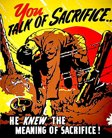
This last poster sums up .... The Meaning of Sacrifice!

WE WILL FOREVER REMEMBER..............2015

Sunday, November 17, 2013

SODA POP, THE KING AND QUEEN, AN OLD LANDMARK, & Homes I lived in back then......

Here are some more then and now items starting off with The Kakabeka Falls Brewing Co. Ltd. here in Fort William Ontario beginning with Big "4" Line soda pop beverages distributed by the KB Falls Brewing Co.  This is a great logo that you may see with a diesel locomotive or a steam locomotive.  The bottles in my collection have silk-screened labels.   The picture below also shows a reverse colour label from Fort William, and another from Sudbury Brewing and Malting Co. Ltd.
Be sure to click on all items for enlargements.


Big "4's"

"Letterhead"
Here is some Northern Breweries history and also the property as it looks today on the corner of Marks and Cameron St.  Clow Darling presently occupies the old brewery property.


THE ROYAL TOUR 1939
The next items on this post refer to a Royal Tour back in 1939 by King George VI and Queen Elizabeth I.  The tour as you can read here was from May 17 until June 15 back in 1939.
HISTORY


Here is the King and Queen as they arrived at the CPR station on Syndicate Ave. in Fort William Ontario.  In the background is the old Ogilvie Elevator which still stands to this very day.


The next photo is that of the King and Queen's motorcade turning south on Memorial Ave. from John Street road, and by clicking on these photos you may recognize some business establishments or houses that still exist to this day.  This things you see in the sky are all the overhead cables for the street cars that travelled these routes....one can be seen in the background waiting to get through.


The final colour photo here is how this same corner looks today.  Some of those tall peaked roof lines are visible in both photos.


NEXT:
The King and Queen in motorcade in front of Central School, the present day site of Patterson Park directly across from the new court house.

The King and Queen in their McLaughlin-Buick touring coach in front of the Pagota on Water Street in Port Arthur.


These next two photos are of the King and Queen signing the city register at the present day corner of May Street and William street just south of the river and across from the old fairgrounds(present day Silver City parking lot.  You can see the river to the left and the elevators in the background.  Either the "Welcome to Port Arthur" arch was not constructed by then or it is just out of the photo to the left.  One photo is an Internet photo and the other is a family photo...each a bit different.  You can just make out the corner of the old Canadian Lakehead Exhibition Grandstand to the right and near top of each photo. 


The picture here shows the exact angle the two photos above were taken.  Even though the wire fence was probably taken down and removed many times in the past...it still looks the same.


Here is a story of the McLaughlin- Buick that King George VI and Elizabeth I used on their tour above. Click On.
NEXT:  I am reversing the order of the following two photos to show the huge difference in this piece of property. 
We all know this as the present day Kam River Park, but it was once a very bustling place.  It used to be the Canadian Pacific Railway freight sheds.  I spent many a day as a kid riding my bicycle down here to see all the beautiful cruise ships that came and went such as the S.S. Assiniboia and the S.S. Keewatin. 


Kam River Park

Here is a wonderful photo of my future mother-in-law with a friend(circa 1940), standing on the pier and behind them is the Canadian Pacific Railway freight sheds and further in the distance is one of the cruise ships mentioned above and also Elevator "B" which would have been at the foot of Victoria Ave.

Next and Finally for this post - "HOUSES" then an now!


The above photo is of the first home my parents purchased at 432 E. Francis Street in Fort William, and this is how it looks today.  It's the only house in the area that has that strange little sloped roof-line in the front.  When we lived there, it had a dug-out basement and I thought it was pretty cool that I could go downstairs and play with my toy cars all winter long.

This is the last photos on this post and showing the home we lived in on Arthur Street in Fort William until I was married.  The old photo above has my dad's '52 Chevy in front with my little sister peering out the window.  I remember actually taking this photo myself in about 1954 and standing pretty much on the train tracks to take it.  The steam engines ran right up Arthur street in those days.  I helped my father build an upper level in the house which would be my own bedroom.

A BIG THANK YOU to all those who loaned or donated photos to this post, previous posts and ones yet to come.  A blog such as this could not happen without great PHOTOS! ☼☼☼

Wednesday, January 20, 2010

Vintage Winter Shots in Port Arthur...Mainly in 1952..


Arthur Street East(now Red River Road) in the winter of 1952...standing on the corner of Court and Arthur looking east towards the lake(very cool old cars and truck). In the old photo further down the end of the street on the left is the Prince Arthur Hotel. The banner reads "Oliver Road Carnival, Feb 15/16 and 17". The best item in this photo is the Colonial Theatre(235 Arthur St...opened in 1935 and closed shortly after this was taken) about halfway down the street on the left. To place yourself today in the photo, the new photo shows the curved corner old Eaton's building on the right, and you can see the same curved corner in the old photo on the right as well.

From the first photo, take an abrupt right-face and look down the sidewalk on Court Street facing south. Firstly you will see an old Dodge then, Francey Drugs, a beauty salon, then the well frequented Birds Restaurant on 12 S. Court(to the right of the photo here is an interior shot of Birds back then, as well as a locator map), then a furrier store, then Farrant and Gordon Men's wear, Willson's stationery and finally the Paramount Theatre(the only original theatre still in business as a theatre today). I just can't quite make out what was showing in January of 1952, but it looks like Jane Wyman in ??? ....Maybe "The Blue Veil".
Here is a matchbook cover from Bird's Restaurant. The B&W photo also from 1952 is St. Andrews Catholic Church taken from Algoma Street facing south. To the very left of the photo today would be the entrance to St. Joseph's hospital. Looks like an early 50's Pontiac and Chevrolet parked there.
Finally, here is a picture of what looks like a Lakehead Motors tow truck yanking out what looks like a Model "A" Ford from the aftermath of one of our Northwestern Ontario snowstorms(photo taken on Feb. 2, 1939). This picture was taken near the corner of John Street and Memorial Ave. facing south(off in the distance you can see all the wonderful trees that used to adorn Memorial Ave., but are long gone). The colour picture was taken in the winter of 2005. There have even been changes to this spot since 2005. The Merla Mae ice cream drive-in on the right has been an icon on Memorial Ave. for many years and is still there today. The colour photo was taken very close to the same location as the B&W.
Click on all photos to enlarge!

Tuesday, October 6, 2009

The Old Canadian National Railway spur in Fort William(Thunder Bay)


Do you recognize the building at the far left of this photo?....Yes it is the Fort William Gardens and this is Vickers Street in Fort William(now Thunder Bay). This photo was taken in the 1950's and since then, the CNR station beside the passenger cars is long gone and so are the tracks, as no locomotives travel any longer down Vickers Street towards Arthur Street, behind the Bell Telephone building, curving towards Arthur Street, travelling down the north side of Arthur and finally turning left right through the new mini golf course and curving behind the Kingsway Motel to finally connect to the main CN line that still goes right through our city. I know that because as a kid I lived on Arthur Street right across from the train tracks. My mother would have a train schedule hand so she would be sure not to hang clothing on the line when the steam train was passing. In the new photo you are looking at an extra wide Vickers Street at this point, but the Fort William Gardens is still there...so far anyway!

Below, and just out of sight at the bottom of this 1940's photo is the tracks that I had explained above. Here, highway 61(Kingsway St) was the main highway into town from the USA. It is interesting to see this photo and the one taken today as the only similar thing in the photo is Mount McKay in the background.

The Kingsway Motel in the photo below is actualy built in a triangular shaped because the train tracks curved from Arthur Street at a tight angle behind the motel to attach to the main line as mentioned above.

I really enjoy these four photos as I actually remember the complete transition. No matter what our city does, it's still sad to see many of our historic buildings disappear into the oblivion.
Thanks for looking and click on to enlarge as usual!